Breadcrumb

Environmental data

From daily weather forecasts, severe storm warnings, and climate monitoring to fisheries management, coastal restoration and supporting marine commerce, NOAA’s products and services support economic vitality and affect more than one-third of America’s gross domestic product.

NOAA’s dedicated scientists use cutting-edge research and high-tech instrumentation to provide citizens, planners, emergency managers and other decision makers with reliable information they need when they need it.


Related Content

U.S. Census Bureau Data Helps Hurricane Dorian Efforts

Blog
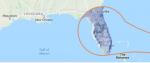
The following is a cross-post from the U.S. Census Bureau Hurricane Dorian is an active tropical cyclone currently threatening Puerto Rico and the Dominican Republic. The fourth named storm of the 2019 Atlantic hurricane season, Dorian developed from a tropical wave in the Central Atlantic. Dorian is a small but potent storm. The U.S. Census Bureau produces timely local data that are critical to...

Robots Probe Ocean Depths in Mission to Fine-Tune Hurricane Forecasts

Blog
The following is a cross-post from the National Oceanic and Atmospheric Administration (NOAA) Four ocean gliders are setting off to sea this week to bring back data scientists hope will improve the accuracy of hurricane forecast models. The robotic, unmanned gliders are equipped with sensors to measure the salt content (salinity) and temperature as they move through the ocean at different depths...

COSMIC-2 Soars Into Orbit Aboard SpaceX Falcon Heavy Rocket

Blog
The following is a cross-post from the National Oceanic and Atmospheric Administration COSMIC-2, a mission of six satellites designed to improve weather forecasts and space weather monitoring, blasted into orbit at 2:30 a.m. ET today, June 25, from Cape Canaveral, Florida, aboard a SpaceX Falcon Heavy rocket. “The COSMIC satellites launched today will play a critical role for forecasters and...

Department of Commerce Releases Report on Critical Minerals

Press releases
WASHINGTON – Today, the U.S. Department of Commerce released the interagency report that was submitted to the President pursuant to Executive Order 13817, A Federal Strategy to Ensure Secure and Reliable Supplies of Critical Minerals. The report contains a government-wide action plan, including recommendations to advance research and development efforts, increase domestic activity across the...

U.S. Secretary of Commerce Concludes Successful 2018

Press releases
The U.S. Department of Commerce was hard at work this year protecting American trade and security interests, reforming outdated government practices, planning the critical decennial census, providing crucial weather information to protect lives and property, stewarding the Nation’s marine resources, in addition to supporting minority and community economic development, among countless other vital...

NOAA Forecasters Lower Atlantic Hurricane Season Prediction. Urge Continued Preparedness and Vigilance

Blog
The following is a cross-post from the National Oceanic and Atmospheric Administration (NOAA) Conditions in the ocean and the atmosphere are conspiring to produce a less active Atlantic hurricane season than initially predicted in May, though NOAA and FEMA are raising caution as the season enters its peak months. “There are still more storms to come – the hurricane season is far from being over...

U.S. Secretary of Commerce Wilbur Ross Issues Directive for National Marine Fisheries Service to Facilitate Water Access in California Wildfire Relief Efforts

Press releases
Statement from U.S. Secretary of Commerce Wilbur Ross As Secretary of Commerce, today I directed the National Marine Fisheries Service to facilitate access to the water needed to fight the ongoing wildfires affecting the State of California. One of the fires, the Mendocino Complex Fire, has developed into the largest in the state’s history, consuming nearly 300,000 acres in Northern California...

Scientists Complete Mission to Map Fast-Moving Fault off Alaska: Data to Help Coastal Communities Prepare for Risks from Earthquakes and Tsunamis

Blog
The following is a cross-post from the National Oceanic and Atmospheric Administration Researchers from NOAA, U.S. Geological Survey and their partners have completed the first high-resolution, comprehensive mapping of one of the fastest moving underwater tectonic faults in the world, located in southeastern Alaska. This information will help communities in coastal Alaska and Canada better...

GOES-S Satellite Launch Set for March 1: Five Reasons Why it Will be a Game Changer for Weather Forecasts

Blog
On March 1, 2018, NOAA’s newest geostationary satellite will launch into space from Cape Canaveral, Florida. GOES-S (which will become GOES-17 once it reaches its final orbit) will significantly enhance weather forecasting capabilities across the western United States, Alaska and Hawaii and provide critical data and imagery of the eastern and central Pacific Ocean extending all the way to New...

NOAA Data Helps Retail and Manufacturing Business Minimize Impacts from Weather and Climate

Blog
The following is a cross-post from NOAA's National Centers for Environmental Information From making sure warm winter coats are in stock at just the right time to accurately evaluating the underlying causes of fluctuations in the U.S. economy, NCEI’s environmental data provide critical information for retailers, manufacturers, and the companies that invest in them. As industries that are highly...